Thank you for your patience while we retrieve your images.
OUTSIDEIMAGES.COM
Home
Nautical Stock Images
Nautical Fine Art Prints
America's Cup Prints
All Stock Images
▼
All Stock Images
▼
Galleries
Across America Stock
America's Cup 2013
Shipping and Transport
NOOD Regattas 2014
J22 Worlds 2013
Louis Vuitton Cup 2013
America's Cup 30 years of
Volvo Ocean Race
Louis Vuitton Sailing
Sailing Events
Sail Boats
Super Yachts
Cruising Boats
Power Boats
Vintage IOR
Boat Works
Boat Tests
Travel
Commercial and Branding
UAE
Lisbon
New Zealand
Spain
Coastlines
Wall Art
Architecture
Photo Editors
Client login
Image Licences/Prints
▼
Image Licences/Prints
▼
Print Orders
Image Licences/Prints
Portfolios
Tear Sheets
Client Login Images
Travel Stock Images
Contact Us
Social Media
▼
Social Media
▼
Books
Facebook
Twitter
Linkedin
Blog
500px
Travel Blog
Live Imaging
Home
»
Nautical and Marine Stock Photography
»
Nautical images , Sailing Photography and Boating Stock Photo Galleries
»
Stock images of Rough Weather Sailing and boating
Visitors
0
« Previous
Next »
425
of
1244
photos
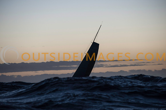
111126_TODD_0984
Image of rough weather sailing in big seas. Well known surf spot Noordhoek Beach (locally known as the Dunes) is best viewed from Chapman’s Peak drive as you can see the immense size of the beach from this high vantage point. The beach is very popular with walkers, horse riders and of course surfers. Two popular surf spots are known as The Hoek and Dunes. There is a well known ship wreck on the beach, called the Kakapo. It can be found towards the left hand side of the beach as you look out to sea. In the 1900’s the ship headed straight into the beach as the skipper thought he had already rounded Cape Point. The beach has soft white sand to walk on and the views of the bay are spectacular. Because of the size of the beach you never get overcrowding that hits other beaches in summer.
Noordhoek is a suburb of Cape Town, South Africa, located below Chapman's Peak on the west coast of the Cape Peninsula, approximately thirty-five kilometres to the south of the city itself. The name "Noordhoek" was taken from Dutch and literally means "north corner". It is best known for its picturesque shoreline and its long, wide, sandy beach, which stretches south to the neighbouring village of Kommetjie. Near the southern end of this beach is the wreck of the steamship "Kakapo", which ran aground about a century ago when the captain mistook Chapmans' Peak for the Cape of Good Hope and put the helm over to port. Noordhoek can be accessed either from the spectacular scenic coastal road, Chapman's Peak Drive, which leads out of Hout Bay or via the mountain road Ou Kaapse Weg which cuts through the beautiful Silvermine Nature reserve - now part of the Table Mountain National Park. Noordhoek is a small scattered community of nice houses, often with sea views and has a large horse population as riding on the long sandy beach is a great attraction. Many artists live in Noordhoek.
©Paul Todd/OUTSIDEIMAGES.COM
OUTSIDE IMAGES PHOTO AGENCY
Categories & Keywords
Category:
Subcategory:
Subcategory Detail:
Keywords:
rough weather sailing
©Paul Todd/OUTSIDEIMAGES.COM
111126_TODD_0984
Image of rough weather sailing in big seas. Well known surf spot Noordhoek Beach (locally known as the Dunes) is best viewed from Chapman’s Peak drive as you can see the immense size of the beach from this high vantage point. The beach is very popular with walkers, horse riders and of course surfers. Two popular surf spots are known as The Hoek and Dunes. There is a well known ship wreck on the beach, called the Kakapo. It can be found towards the left hand side of the beach as you look out to sea. In the 1900’s the ship headed straight into the beach as the skipper thought he had already rounded Cape Point. The beach has soft white sand to walk on and the views of the bay are spectacular. Because of the size of the beach you never get overcrowding that hits other beaches in summer.
Noordhoek is a suburb of Cape Town, South Africa, located below Chapman's Peak on the west coast of the Cape Peninsula, approximately thirty-five kilometres to the south of the city itself. The name "Noordhoek" was taken from Dutch and literally means "north corner". It is best known for its picturesque shoreline and its long, wide, sandy beach, which stretches south to the neighbouring village of Kommetjie. Near the southern end of this beach is the wreck of the steamship "Kakapo", which ran aground about a century ago when the captain mistook Chapmans' Peak for the Cape of Good Hope and put the helm over to port. Noordhoek can be accessed either from the spectacular scenic coastal road, Chapman's Peak Drive, which leads out of Hout Bay or via the mountain road Ou Kaapse Weg which cuts through the beautiful Silvermine Nature reserve - now part of the Table Mountain National Park. Noordhoek is a small scattered community of nice houses, often with sea views and has a large horse population as riding on the long sandy beach is a great attraction. Many artists live in Noordhoek.
©Paul Todd/OUTSIDEIMAGES.COM
OUTSIDE IMAGES PHOTO AGENCY