Thank you for your patience while we retrieve your images.
Visitors 1


« Previous Next »
38 of 1529 photos

131207_TODD_00868

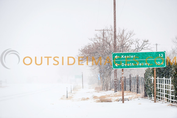
Owens Valley and Death Valley (USA, CA) December 2013. Driving through the long straight roads in Death Vally National Park. Death Valley is a desert valley located in Eastern California. Situated within the Mojave Desert, it is the lowest and driest area in North America, and currently the hottest in the world. Death Valley's Badwater Basin is the point of the lowest elevation in North America at 282 feet (86 m) below sea level. This point is 84.6 miles (136.2 km) east-southeast of Mount Whitney, the highest point in the contiguous United States with an elevation of 14,505 feet (4,421 m). Death Valley's Furnace Creek holds the record for the highest reliably reported air temperature in the world, 134 °F (56.7 °C) on July 10, 1913. Located near the border of California and Nevada, in the Great Basin, east of the Sierra Nevada mountains, Death Valley constitutes much of Death Valley National Park and is the principal feature of the Mojave and Colorado Deserts Biosphere Reserve. It is located mostly in Inyo County, California. It runs from north to south between the Amargosa Range on the east and the Panamint Range on the west; the Sylvania Mountains and the Owlshead Mountains form its northern and southern boundaries, respectively. It has an area of about 3,000 sq mi (7,800 km2). Death Valley is one of the best geological examples of a basin and range configuration. It lies at the southern end of a geological trough known as Walker Lane, which runs north into Oregon. The valley is bisected by a right lateral strike slip fault system, represented by the Death Valley Fault and the Furnace Creek Fault. The eastern end of the left lateral Garlock Fault intersects the Death Valley Fault. Furnace Creek and the Amargosa River flow through the valley but eventually disappear into the sands of the valley floor.
©Paul Todd/OUTSIDEIMAGES.COM
OUTSIDE IMAGES PHOTO AGENCY

Categories & Keywords
Category:
Subcategory:
Subcategory Detail:
Keywords:California, Death Valley, Desert, HORIZONTAL, Lone Pine, Mount Whitney, Mountains, Owens Valley, Travel, USA, United States, White Mountains, america, arid, badlands, beautiful, beauty, dawn, death, death valley national park, desert southwest, desolate, desolation, dry, dune, eco tourism, erosion, erosional, geologic, geologic forces, geological, geological forces, geology, hot, landscape, landscapes, loneliness, national, national park, natural, nature, outdoor, outdoors, park, rugged, sand, scenery, scenic, sky, southwest, sunrise, sunset, valley, vertical, wilderness, winter, zabriskie

131207_TODD_00868

131207_TODD_00868

Owens Valley and Death Valley (USA, CA) December 2013. Driving through the long straight roads in Death Vally National Park. Death Valley is a desert valley located in Eastern California. Situated within the Mojave Desert, it is the lowest and driest area in North America, and currently the hottest in the world. Death Valley's Badwater Basin is the point of the lowest elevation in North America at 282 feet (86 m) below sea level. This point is 84.6 miles (136.2 km) east-southeast of Mount Whitney, the highest point in the contiguous United States with an elevation of 14,505 feet (4,421 m). Death Valley's Furnace Creek holds the record for the highest reliably reported air temperature in the world, 134 °F (56.7 °C) on July 10, 1913. Located near the border of California and Nevada, in the Great Basin, east of the Sierra Nevada mountains, Death Valley constitutes much of Death Valley National Park and is the principal feature of the Mojave and Colorado Deserts Biosphere Reserve. It is located mostly in Inyo County, California. It runs from north to south between the Amargosa Range on the east and the Panamint Range on the west; the Sylvania Mountains and the Owlshead Mountains form its northern and southern boundaries, respectively. It has an area of about 3,000 sq mi (7,800 km2). Death Valley is one of the best geological examples of a basin and range configuration. It lies at the southern end of a geological trough known as Walker Lane, which runs north into Oregon. The valley is bisected by a right lateral strike slip fault system, represented by the Death Valley Fault and the Furnace Creek Fault. The eastern end of the left lateral Garlock Fault intersects the Death Valley Fault. Furnace Creek and the Amargosa River flow through the valley but eventually disappear into the sands of the valley floor.
©Paul Todd/OUTSIDEIMAGES.COM
OUTSIDE IMAGES PHOTO AGENCY